
|
|
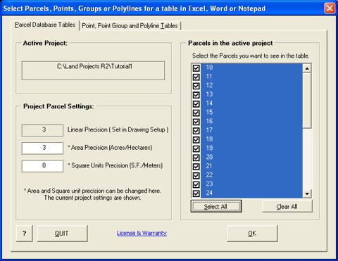
GetParcels for
| |||||||||||||||||||||||||||||||||||||||
|
|
||
|
Land Development Desktop 2i - 2008 graphic: |
||
|
*** Create parcel area tables*** Create polyline area tables *** Non-Word/Excel versions are included *** |
|
*** Create selected point data tables *** Create point group data tables *** |
|
GetParcels creates Parcel or polyline area tables or point/point group data tables in *Word, Excel, Notepad or LDT by exporting the data from Parcel area files (or directly from LDD2i+). Tables contain the name, perimeter, square footage and acreage as well as the number of parcels, minimum parcel size and name, maximum parcel size and name, average parcel size, the name of the project and date of creation. *Word/Excel are not required to use the program. |
|
|
GetParcels can also be used to create area tables in AutoCAD from selected polylines. |
|
|
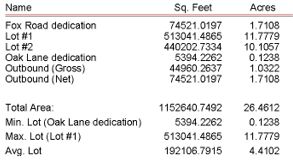
The Parcel Area tables look like this: |
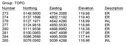
The Point tables look like this: |
 |
 |
Land Development Desktop 2 (or higher) |
|
Registration Cost: |
|
$99 Per Office location |
|
| To purchase with any major credit card over a secure connection: | |
| To be billed: | |
| Just e-mail the registration form to billing@budcad.com, we will send the authorization, registration number and invoice right away. | |
|
AutoCAD, Land Desktop and Civil 3D are trademarks of Autodesk. All other products mentioned are registered trademarks or trademarks of their respective companies. Questions or problems should be directed to Webmaster@BudCAD.com. Copyright 2000-2008. All rights reserved. |